How Remote Sensing Analytics can keep offset costs down and habitat value up.
Whether you are a land developer, an oil and gas producer, a farmer, a statutory authority or a community environmental group, vegetation has value. Most statutory authorities have vegetation offset policy that seeks to place on a monetary value on the intrinsic bio diversity value of vegetation and habitat. In some sectors this value is offset or traded based on an attributed value. Under this legislative framework accurately and precisely identifying vegetation and habitat value is critical for all stakeholders.
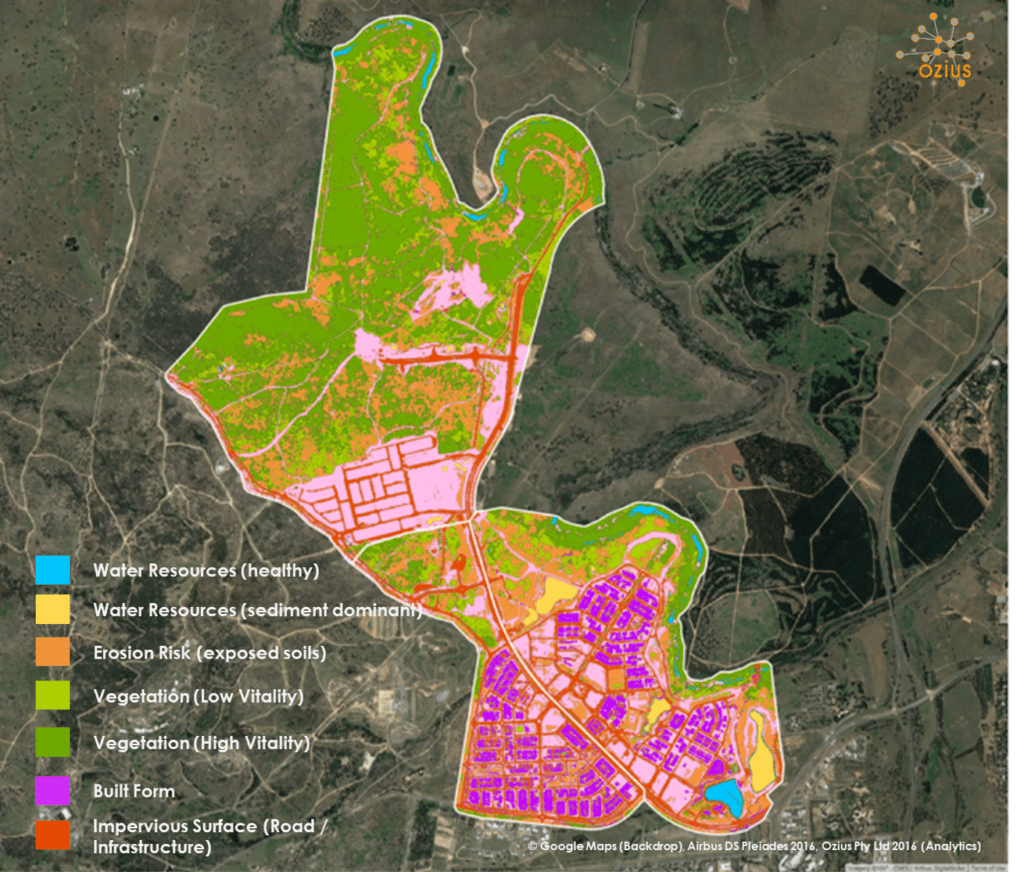
It’s not uncommon these days to incorporate some form of GIS solution into environmental monitoring programs, whether it’s mapping vegetation extents or identifying key habitat areas. Most statutory bodies are using GIS in varying degrees to producing maps to inform policy. These sorts of maps are (or at least should only be) used to provide indicative areas of interest such as remnant vegetation, steep slopes, bushfire etc etc.
Why are they only indicative? Because they are designed to say, “hey, if you are thinking of developing, constructing or clearing in this area, we (“the government”) may want to talk to you before you progress too far!” From here the affected entity (in this case I will refer to them as “the developer”) is usually required to obtain some form of statutory permit or approval. This is where the journey begins.
In very simple terms the journey may go a little something like this…
The developer proceeds to engage an environmental consultant to undertake a more accurate assessment of how much of the “protected” vegetation or habitat is or won’t be affected by their works. It’s not uncommon for the environmental team to use a field team in conjunction with some aerial imagery and in some cases also some Lidar, to more accurately detect the habitat or trees of concern. Following this, an analysis is undertaken and a report submitted to the relevant statutory authority for a decision. From here, I’m sure professionals from both sides of the fence could recite tales of heated debates, the back and forth discussion over whether or not the lidar is calling a shed roof a cluster of trees or whether a cluster of trees is remanent or an olive grove or whether re-growth on an abandoned dairy farm is being called remnant and subsequently included in the financial offset calculation. Right or wrong, these are not made-up or fanciful examples – I’m sure you get my point, that is, things rarely go smoothly during the decision process.
How do you make things go a little more smoothly? Both sides of the fence should embrace, understand and utilise remote sensing analytics to create more accurate GIS layers as an input into their Environmental Assessment or decision making processes
If you or your GIS team find yourselves digitising images, drawing polygons over 100’s of hectares or removing artefacts manually from noisy Lidar data, stop! You’re actually doing it the hard way!
In our previous post, data, data and more data, we spoke about data quality and ensuring the data you purchase and use, whether is Lidar, aerial or satellite, is of a high quality, complete (you got every bit of data, not just a nice flat image) and fit for purpose. Remote sensing uses ALL the data, behind the aerial or satellite images (and also Lidar) to enhance, extract, and analyse information. If your data is of an acceptable standard, a proven and robust remote sensing methodology can be applied correctly, and it can then be automated.
Why should I use Remote Sensing Analytics?
If you are involved in land acquisition and planting for the purposes of vegetation offsets, remote sensing analytics you can consistently and accurately obtain information that helps inform your future land purchases and monitor your planting and rehabilitation regimes. You can do this at an individual site scale or at a regional scale.
With the right data you could also monitor re-growth over time which may greatly assist financial offset obligations and requirements.
Remote Sensing Analytics is the perfect tool to assist your Ecology specialists and better inform the work they undertake. Ultimately it means they can spend less time in the field, or can be more surgical in their approach, no matter what side of the fence you sit on, this can only save you time and money.
For statutory authorities, you can improve the accuracy and precision of the GIS layers and mapping that inform your policy. This means you can lessen the traditional arguments and debates with industry sectors. It also provides your stakeholders and customers with more certainty. This will improve the overall efficiency of permitting and compliance.
Other uses for Remote Sensing analytics in environmental assessment include:
- Site identification and suitability
- Pre-field work analysis environmental compliance and monitoring
- Monitoring operations including vegetation offsets planting
- Identifying vegetation offset requirements (for use in calculating financial offsets and compensatory planting)
- Monitoring natural environmental impacts such as recovery from fire
Accurate and precise information can keep your operations running more efficiently, it can keep you development or construction costs down and it can also protect the value of our habitat. That’s a triple bottom line benefit, maybe even quadruple bottom line.